Hospitals, schools, kindergartens and gas – Assad’s latest war crimes remain unanswered.

During the last days, Syrian dictator Bashar al-Assad and his Iranian/Hezbollah/Russian-supported regime army proved once again that it hasn’t reached its peak in inhuman and war-criminal behavior yet so far, but works hard to reach that goal.

Since last weeks fall of Busra al Sham in southern Daraa province and Idlib city in the alike-name province, the regime further perfected its terrorism against the civilian population, mainly targeting hospitals and schools in the liberated areas as well as using gas-attached barrel bombs on a daily basis.

Clear evidence from southern Syria shows that schools and kindergartens under the control of the Syrian opposition become a deliberate target for the regime air force while they were more or less indiscriminately hit so far (Evidence 1 from Damascus, 2 from Kwdana and 3 from Busra al Sham). Especially the hit school in Kwdana, which was hit by a missile, fired from a regime jet, is worth a mention, as it is located exactly 693 meters(!) from the ceasefire line “Bravo”, agreed on after the Yom Kippur war (picture). Neither Israel nor the UN transmitted a complaint or stopped the Assad air force from bombing civilian targets that close to the buffer zone.

kwdana

missile-hit school

Meanwhile in Idlib city, which fell recently under a coalition of several moderate to extremist rebel groups, the Assad regime started a bombing campaign on the civilian infrastructure after losing the important town. While this is seen in all regime-lost cities, the regime decided this time to use an extraordinary sinister tactic of first destroying all hospitals in the city, parallel and before starting to raid more residential areas. In this context, the city’s main “National Hospital” as well as the headquarters of the Syrian Red Cross ( resp. Red Crescent were hit in coordinated strikes on March 30.

national hospital

missile- and barrel bomb-hit hospitals

At the same time, the Assad regime bombs quarters across the city, using jet-fired missiles, helicopter-dropped barrel bombs as well as surface-to-surface missiles, trying to achieve maximum casualties among the civilian population. Many of his barrel bombs are equipped with Chlorine gas canisters to increase the terror for the hit people. Hence, the occurrence of (gas) bombing victims of all religions becomes an increasingly common appearance in the now-free, but hard-hit city (see pictures below).

gas victim

gas victims and canisters

flat destroyed

bomb–hit flat

Last but not least, its must be said that the international reaction to all these WAR CRIMES is zero, talking about other Arab states, being involved in the Yemen campaign as well as Europe and the United States, being busy with reaching  a deal with Assad’s main sponsor Iran. These nuclear negotiations seem to give the “Butcher of Syria” a free ticket to continue his reign and atrocities on a daily basis. But not only he benefits from the international blind eye. Also the “Islamic State” terror group and its sympathisers in European countries profit from the inaction, as it is fueling their narrative of an “idle (or even “supportive”) West while muslims are slaughtered”. In the end, this development will not only lead to more sorrow among the Syrian civilian population (and thus more refugees abroad), but could also fuel anti-Western tendencies among muslims in Europe and thus increase the chance of more IS-related terror attacks like we saw them in Paris and Copenhagen.

A concentration camp on the doorstep – “life’s little pleasures” of Syria’s Bashar al-Assad

WARNING: This report shows and links to the most graphic images of tortured-to-death people, you can imagine.

On March 17, 2015, the Syrian-Arab news site “Zaman al-Wasl” published, what it says were leaked pictures of Assad regime atrocities, committed in the Syrian capital Damascus between 2011 and 2013. Despite the pictures – part of a 55.000 files package – have been leaked since mid 2013 and confirmed real by CNN and the Guardian newspaper in January 2014, they have never been published since then for no know reason. Until now.

What the pictures show is difficult to describe as hard to bear. Famished bodies of men, women and children, obviously tortured and starved to death and what seems to be a former military hospital, now (at least until 2013) being used as a concentration and death camp to detain, torture and kill people, seen as disloyal or dangerous to the regime of Bashar al-Assad.

child

However the freshly released picture do not only show the unimaginable war crimes of a dictator, who’s methods and cruelty can be well compared to Nazi Germany’s Adolf Hitler; they also allow for the first time a geolocation of one of the death camps, revealing unbelievable facts.

The pictures of some 20-30 dead people were taken in the yard of an army facility in the the upper Damascus quarter of Mezzeh in the north west of the Syrian capital, which also houses the palace of the “president” (illegal dictator) himself. And that is not all. A precise geolocation of the place could be established on the day of the release of the pictures, revealing that the concentration and death camp is located less than 500 meters downhill from the presidential palace, unveiling and unbelievable spatial proximity between the suspected whereabouts of the dictator and his family on the one side and the location of the worst imaginable atrocities on the other side.

map damascus

Using the possibilities of Google Earth, yet more terrifying details emerge. There was (or still is) indeed a direct sight line between the rear part of the Assad family’s palace and the located death camp, meaning it was theoretically possible for Assad, his family and his allies as well as international political guests to see with their own eyes what kind of war crimes, the regime is involved, namely killing tens of thousands of Syrians, not willing to obey the orders of the regime or just being members of the “wrong” religious belonging.

balcony

While it can not be proven, anybody ever took a look from the palace at the well visible bodies in the nearby death camp, it remains more than odd that the Syrian dictator took the risk of heaving his war crimes being established so close to his physical presence, family and international guests – mostly supporters of him and his policies. Hence the possibility that the visual axis was established deliberately to brag about the death machinery to guests or even “engage” in an abnormal “hobby” must be seen as likely.

Last but not least, a look at the possible extend of the war crimes is also possible with the latest geolocated pictures. The two military buses in the picture could have been used to transport detainees to the facility and torture and kill them there afterwards. This is more than a guess. The facility concerned was regularly covered by satellites since the year 2000. In the first 23 images, there are no buses parked on the yard. This changes in May 2012. Suddenly a bus appears on the yard, which has never been parked there before. The next 6 orbital images from 2012 show one bus standing at the yard of the camp in each(!) picture. All three satellite pictures from 2013 show two buses in the area. Just as the latest image, which is from January 2014.

busses

It doesn’t need much fantasy to imagine, why these buses suddenly appeared parked on the yard on EVERY satellite image since early 2012 and are also present on the released pictures … I still gave some hint on the picture above.

While leakers can publish evidence from Bashar al-Assad war crimes and online analysts can make sens of them, it remains to be up to the mainstream media to communicate such findings to decision makers. Finally, it is those decision makers, who have to draw the right conclusions and ACT accordingly.

To offer fresh talks to a regime, which’s crimes against humanity are only comparable to those, committed by the Nazi regime in the 1940s, is not just a punch into the face of those actors, just described but also the highest possible disrespect to the victims of that very regime.

Syrian rebels capture Shaykh Maskin in southern Syria

In mid December of last year, I wrote a large article on the The Battle of Shaykh Maskin” describing how that battle between mostly moderate and Arab states-backed rebels – the so-called “Free Syrian Army” – and troops of the Assad regime developed. At this point, rebels were able to capture and secure some 75% of the city, however most of its strategic military installations remained under the control of the Syrian regime army. Shortly after that article – around Christmas 2014 – severe winter started in southern and central Syria,  stopping most of the fighting for a couple of weeks. It became very quiet around this stratagic town of Shaykh Maskin, being the gate to Izraa and Garfah, both located on the M5 highway, the only remaining land bridge between the regime-held Damascus area and the major city of Daraa in the south of the country.The attached map (not by me!) show how thin the respupply line to Daraa is right now and that regime forces are under extreme threat to lose its remaining strongholds in the south.

B8ROrc2CQAA9j6l

The situation in Daraa province in January 2015

Cutting this bridge would at the same time equal a huge advantage for rebels in Syria’s south, one of the last places across the country, where the pro-democracy revolution was not hijacked by islamist extremists or – literally – destroyed by the Assad regime.

Howsoever, information started to flow again on January 25, showing major developments on the fronts across the northern part of the city. This indicates that the (almost) media blackout over the last month was deliberately to not reveal too much about the usage of fresh weapons and troops used in the offensive. From precisely geolocated footage, it became clear that rebels were able to capture all remaining military installations across the town, namely the Brigade 82 headquarters on a hill overlooking most of Shaykh Maskin, the main base to the north east of the town, the radar base where rebels were able to seize an SA-6 and the weapons storage base some 3 km north of the city. The below map shows all advances between mid December 2014 and January 26 2015.

shaykh maskin

Strategical map of Shaykh Maskin, January 26 2015

The battle for Shaykh Maskin lasted from for a duration of almost 3 months and ended with the total victory of Free Syrian Army and other rebel forces. This is another indication that – different from the Damascus region, Aleppo and areas mostly to Syria’s western borders (with the sea and Lebanon) – the regime control over southern Syrian is increasingly diminishing and about to collapse during 2015. This can be mainly explained by the close-by Syrian-Joranian border via which weapons and trained fighters seem to enter Syria since several years, sometimes more, sometimes less. Those forces are trained and armed by other Gulf states with the consent of the United States, being proven once again by the modern weapons used in the battle for Shaykh Maskin and its eventual fall to the rebel army.

“The Battle of Shaykh Maskin” – in depth war reporting, using the tool of footage geolocation

Introduction

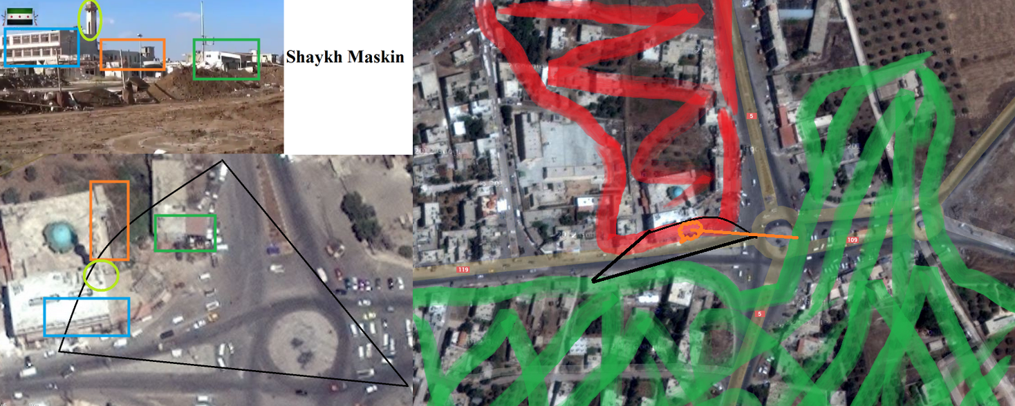
If someone would ask me for the way from the main intersection in Shaykh Maskin’s to the north eastern hill where the Brigade 82 headquarters are based, I could probably give him directions without ever having been in the city or even the country. Moreover, I would be able to tell him, until what point he would be moving in rebel territory and at which street, he would have to choose whether to take cover or run over to the Assad regime side… No one will ever ask me and I won’t give directions.

The point I want to make is that by reviewing multiple video angles of the town from recent rebel footage and comparing these with google maps and bing maps satellite images, I got able to tell, who is watching from which point into which direction and what this means for the viewer and the sighted objects.

When it comes to reporting on war, this analytical process, called geolocating, can turn out to be extraordinarily important as it allows to determine fighting action on the meter exactly, without relying on reports of either side of the conflict, whitewashing their “facts” in their particular favor in 99% of all cases (no offense as perfectly understandable). Moreover, it allows to follow conflicts closely and report on their progression, without risking one’s life. This becomes particularly interesting, talking about conflict zones, far too dangerous to send in neutral journalists.

Body

Coming back to the Battle of Shaykh Maskin, this fight serves as a perfect example for tracking frontline developments in an urban warfare situation from social media footage. I will describe how the battle proceeded, solely using my analyzed and geolocated rebel videos over the last 7 weeks. Altogether, I included some 200 videos from 15 rebel factions, ranging from Free Syrian Army brigades over moderate islamists from the Islamic Front to islamist fighters from Jabhat al Nusra, often described as a local branch of al-Qaeda.

In late October, Syrian rebels started their offensive on the Assad regime-held bases east of Nawa, resulting in the capture of at least 9 military installation between Nawa and Shaykh Maskin.

Nawa

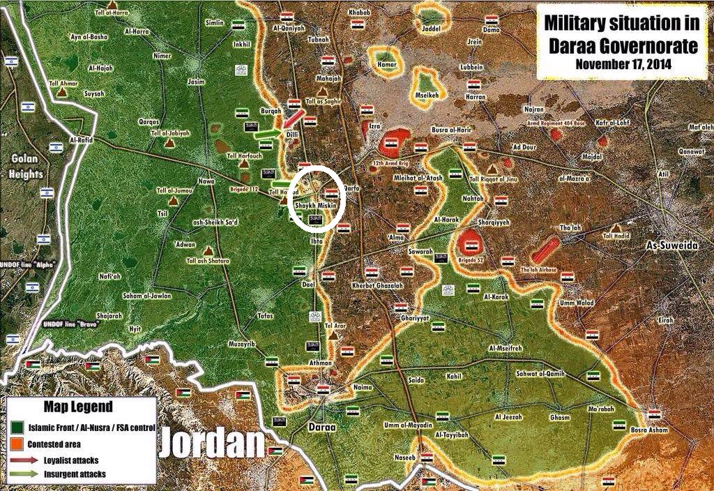
Rebel gains around Nawa in early November, paving the way to Shaykh Maskin

These victories paved the way for the start of the offensive on the regime stronghold of Shaykh Maskin itself. While Nawa is the second biggest town in Daraa province, however not extremely strategically important beside that fact, Shaykh Maskin is the last regime-held city before the highway M5, which connects regime-held Daraa city with the greater Damascus area.  If it falls, Daraa city would be under threat of becoming besieged by rebels, which would result in the toal collapse of the Assad regime rule over its southern region.

Daraa map

Map from mid November by @PetoLucem

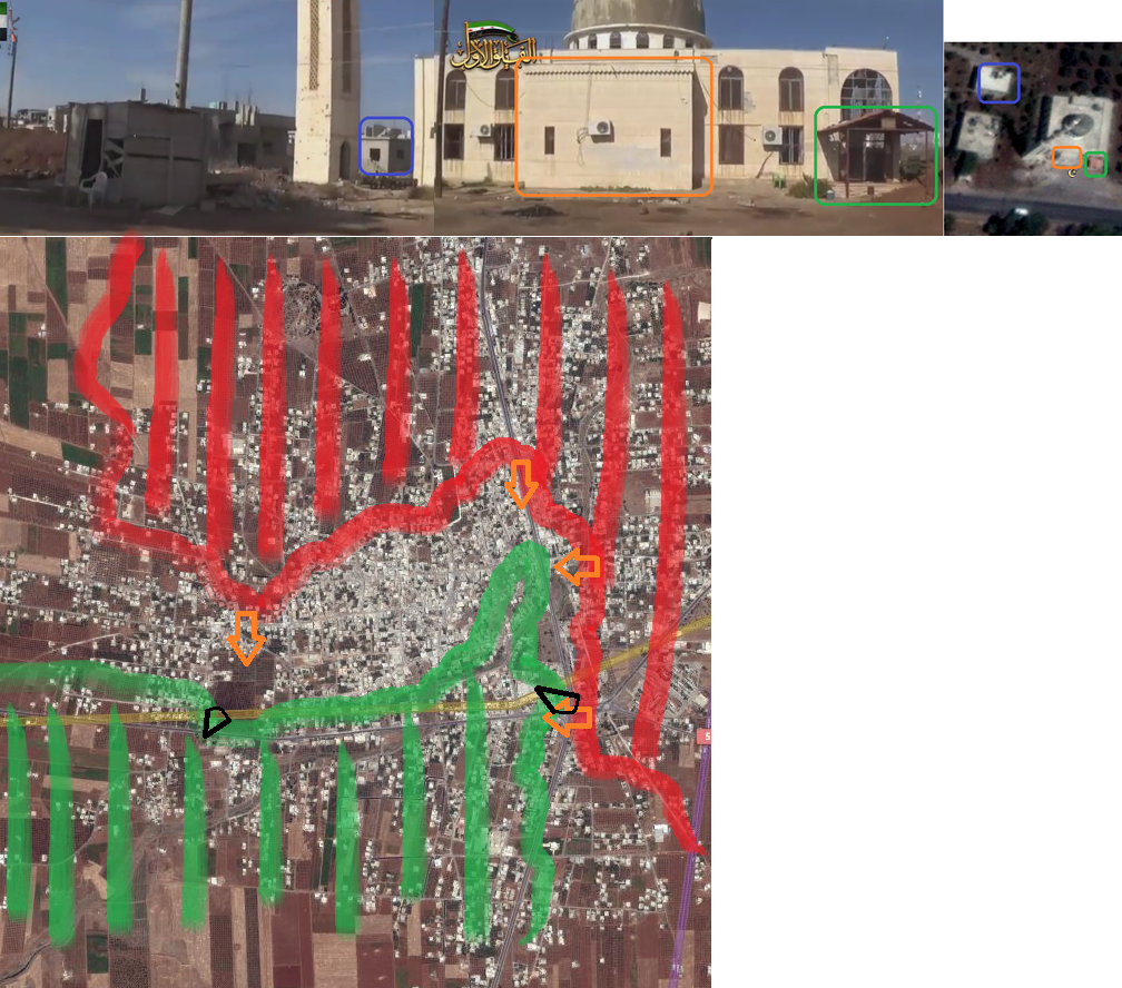
The battle started November 1st, when rebels attacked the west and south west of the city. Due to the recent regime losses around Nawa, the defense of the city was weak and rebels forces needed only 5 days to occupy the entire south west. This enabled them tp launch an assault on the central intersection with the largest city mosque and main road barrier.

Shaykh Intersection

Rebel attack on central intersection barrier November 6

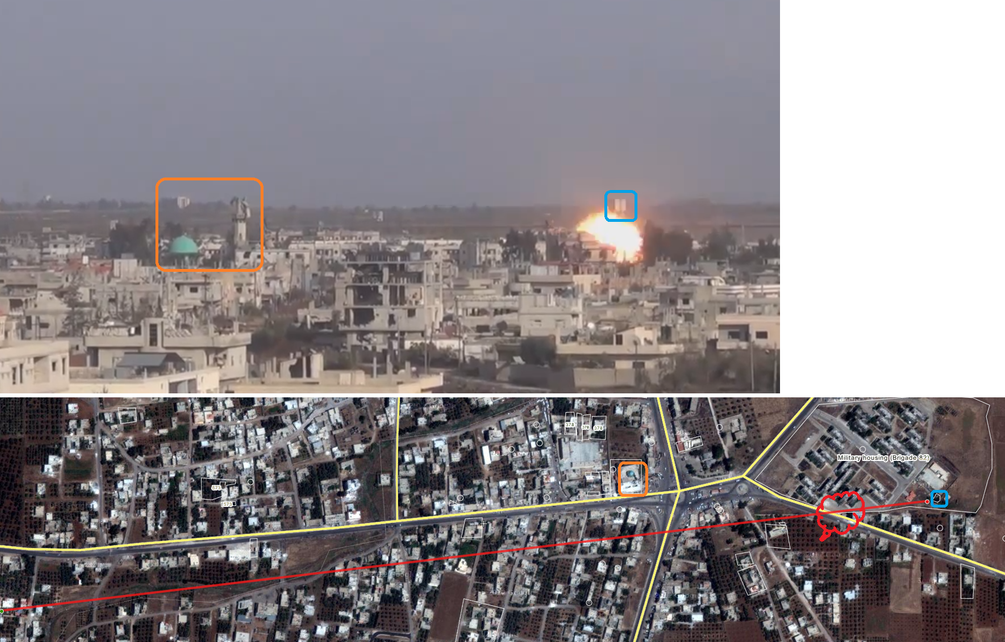
Shortly after the intersection and mosque were taken, however the Assad regime started to send reinforcements, coming from the east and north, so nearby towns like Izraa, but presumably also Damascus itself. Shortly after, rebels were in pssession of the mosque, but didn’t control the intersection anymore, from which they started their assault.

mosque taken

View from the taken mosque on the embattled intersection

At the same time, rebels tried to advance north, attacking the Brigade 82 headquarters of the city. However, due to massive Assad regime reinforcements, strengthening the different Brigade 82 complexes in the city, the rebel army started to face a two-front war, being attacked from the housing complex of Brigade 82, located in the south east, as well as the headquarters of the Brigade, located in the north. Additionally, regime forces were pushing down the north-south road, coming from the north east of the city, where there are several towns and wide strips of land under Assad regime rule. At the same time, Assad air force jets bombed rebel forces as well as civilian areas in the city, making it extremely hard to advance for rebels and even letting them lose some of the before-held territory.

retreat

Regime counterattack, November 21

In this situation, only something dramatic could save rebels from being entirely pushed out of the city and towards Nawa in the west. This dramatic change came, when strong reinforcements from the Jabhat al Nusra islamist extremist group arrived in the city in late November. They added what moderate rebels, using advanced weapons (like the Saudi-supplied TOW), needed to succeed: Manpower and “absolute devotion”, meaning the willingness to not just win and survive the battle, but also sacrifice for this goal as a tactical mean … talking of suicide car bombers.

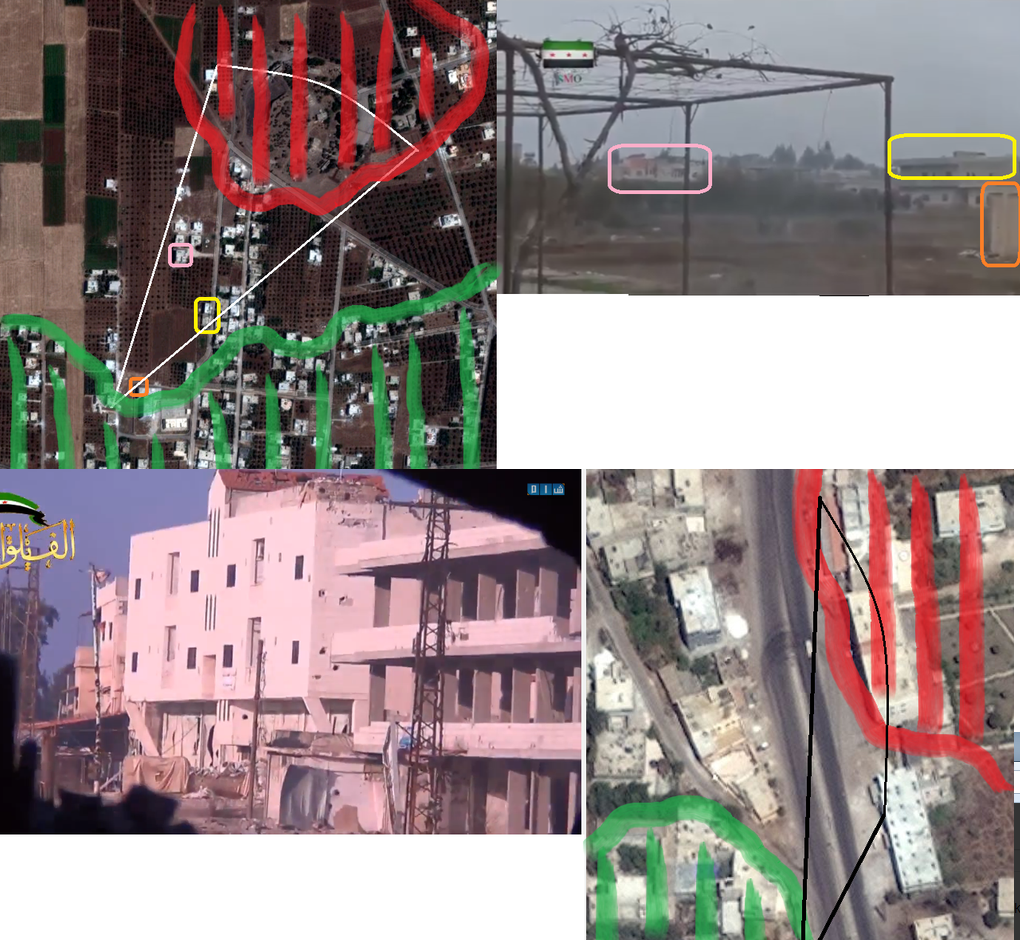
On December 7, two suicide bombers, using BMP ambulances rammed their vehicles into the Brigade 82 housing compley, destroying wide parts of the base.

svbied1

First SVBIED, Dec 7

svbied

Second SVBIED, December 7

This massive attack did not only stop the regime’s assault from the east of the city. Furthermore, it enabled rebels to attack and take the housing complex, effectively returning to a one front war towards the northern parts of the city. The suicide bombings caused massive destruction, leading to the collapse of several of the Brigade 82 housing area barracks. Between 20 and 50 Assad troops died in the assault. The rest fled to Izraa and Garfah.

svbiedafter

Aftermatho of the double SVBIED attack.

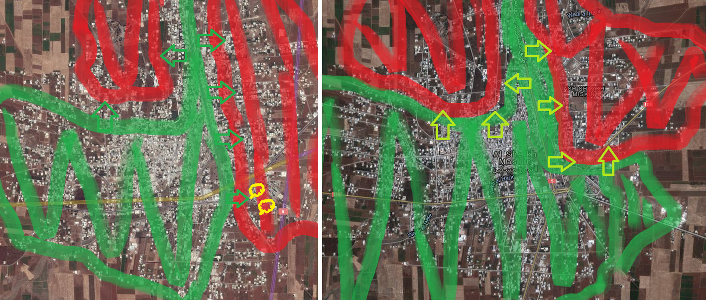
A short Assad army counteroffensive on December 8  coming from the S-E was fended off and within a couple of days, rebels were in a far better position, being now able to focus on the northern parts os the city. The two maps for comparison show the location of the two suicide BMP bombs as well as the directions of the rebel assault after victory in the south east.

map after svbied

On December 9, the offensive on the Brigade 82 headquarters got intensified. Using small arms, mortars, but also ATGM and TOW, rebels launched hit after hit vs. regime troops, which were – and are – still resupplied from the north and the north east of the country. It becomes clear that no quick victory, like it was seen in the south east, is in sight in the north. Partly due to the superior position of Assad forces on the two heavily fortified hills, partly because Jabhat al Nusra seems to have withdrawn again from the battlefield, taking its 100+ men with them, leaving the offensive to not more than 300 FSA and moderate isalmist forces.

brig82-1

Territorial gains for rebels during the first half of December 2014

brig82-2

Attacks on Brigade82 and the eastern side of the main N<>S road

Despite tough battles and very slow rebel advances, progress for rebel forces is visible and the chance of Assad bouncing back seems very small.

On December 18, a number of videos appeared, making it possible to geolocate the current frontline in the city, slowly but continuously moving northward, indicating the liberation of another city from the grip of the Assad regime. At the same time, there is still heavy resistance from fanatic Assad-supportive troops, willing to risk everything for their loyalty to the country’s dictator. One indication of a long battle ahead is the – possible – recapture or eager hold on one high rising sniper position, very close to the center of the town.

brig82-3

View on the Brigade 82 hq and strategic situation map on December 18

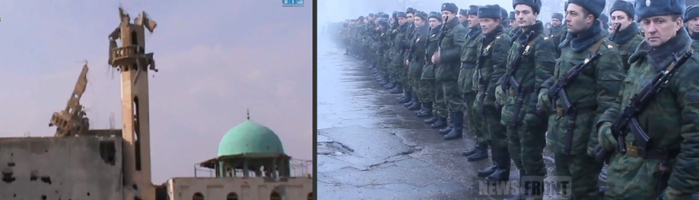
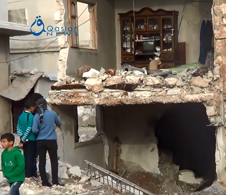
However the sooner or later coming total defeat of the regime in Shaykh Maskin does not mean an immediate ease for the inhabitants of the town as the Assad regime follows the policy of scorched earth, bombing all lost areas – from the air – even harder than during military engagements in the respective territories.

Conclusion

The article at hand summarizes the footage analysis and locating work of more than 7 weeks. It shows that geolocating footage from ongoing battles and too-dangerous-to-enter war areas can lead to a deep understanding of the regarding conflicts in a journalistic as well as military-strategic respect. Therefore, I will continue using this instrument as a main tool of my work, trying to make sense of ongoing conflicts and describe them beyond “reported” or rather “claimed” and thus doubtful communiques from the involved actors on the ground. Last but not least, the battle for Shaykh Maskin is not over yet and I will consider writing a “part 2”, in case of decisive developments on the ground.


All sources in my Twitter feed between November 5 and December 18.

Tracking the Islamic State’s advance towards Deir Ezzor airport

Islamist terrorists and airplanes make a bad mixture, which is not only known since the 9/11 attacks. This might be one reason, why advances of the so-called „Islamic State” on airports are monitored with even greater concern than its general military gains – and losses – in Syrian and Iraq.

Despite the fact that the Islamic State controls some three to four landing strips in the two countries and was never able to start a single manned aircraft from these, its well-known assault on Deir Ezzor airport (map below) is not just a worry to the Assad regime, which holds it right now, but also to regional and western strategists, fearing fighter jets, helicopters as well as loads of heavy and advanced weapons could fall into the IS’ hands.

1The airport of Deir Ezzor

The Islamic extremist organisation is controlling wide parts of Deir Ezzor city since months, which is located north east of the airport. However vague reports emerged over the last weeks, its troops are directly advancing on the airstrip. While this was harshly rejected by the Assad regime ministry of information, western intelligence agencies as well as major news portals had no information on the issue for weeks. On the other side – always “optimistic” – written claims by the terrorist organisation itself normally cannot be checked and thus have to be taken as unconfirmed, mostly exaggerated propaganda.

Therefore to get to know the real extent of the territory the IS controls and the gains or losses they make remains only one promising way, which is the geolocation and analysis of their posted videos.
Doing this over the last days I discovered that their advance on the airport itself moved further than most people expected (scroll down for my source tweets). By precisely geolocating their videos it can be observed that they bypassed the city itself, advanced from the south east and took up positions, which are only 300 meters away from territory of the airport itself and not more than 600 meters from the runway and apron (see map below).

2Identified IS positions near the airport

Given the fact that they seem able to hold these areas for days or more, two different conclusions can be drawn.
First, the Assad regime forces in the area seem to be thinned out and not strong enough anymore to counterattack these strategic positions and push back the IS troops from the perimeters of its airport. This is a telling aspect as it suggests, Assad as well as IS troops have approximately the same military strength in the area. At the same time both sides are weakened from battles at other frontlines, which do not run to their favour.

Second, it can be assumed that at least fixed wing aircraft are not able to approach or take off from the south eastern direction of Deir Ezzor airport anymore as IS troops have positioned heavy machine guns in the area. These would be a far too big threat to low-flying aircraft. This means that – at least for now – the Assad regime cannot use its biggest advantage in the war in Syria, which has always been its air force.

Finally, some final conclusions can be drawn from the most recent developments in the area. While the current advance and possible takeover of Deir Ezzor military airport by the Islamic State might be no big challenge for western governments and might not increase the threat level of aircraft-related terrorist acts, it might deal a deadly blow to the aspirations of the Assad regime in eastern Syria. The fall of Deir Ezzor airport would further weaken the Syrian dictator’s regime in an area, he already lost significant stretches of land and has little to no resources to fill up its thinned out ranks.

Last but not least it has to be said that without the detailed geolocation of recent IS operational videos from the area, no reliable information at all would be available and no conclusions could have been drawn.


Source tweets, featuring the conducted analysis and geolocation of the IS video:

https://twitter.com/Conflict_Report/status/542743194371620865

https://twitter.com/Conflict_Report/status/542717145600499712