The Ukrainian line of defense further collapses – the fall of Nikishyne

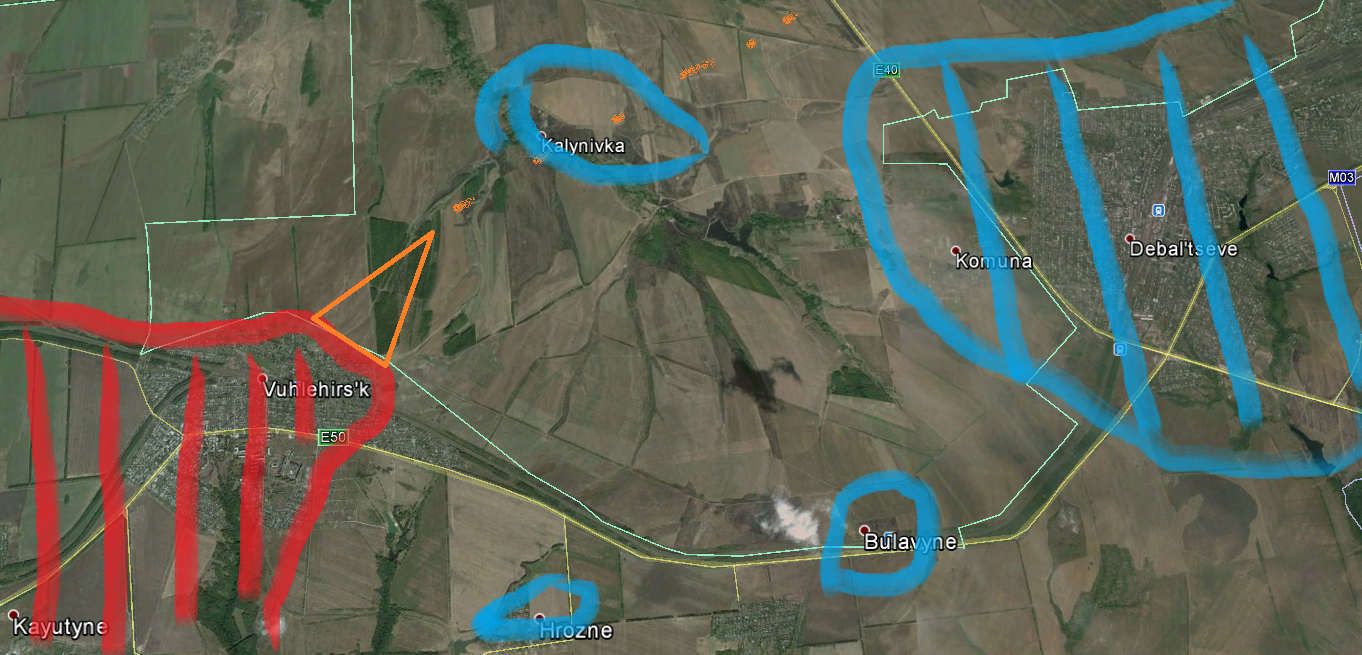
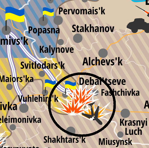
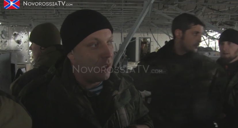
The situation around the Ukrainian city of Debaltseve remains extremely difficult to assess with different sources – even of the same side – announcing totally different situation reports, especially from the embattled town of Vuhlehirsk. While the Russian side claims, it not only holds the town, but extended its controlled territory some 4 km to the north, taking the village of Kalynivka and controlling the M03, effectively closing the pocket around Debaltseve, Ukrainian sources paint a sharply different picture of the situation. Depending on the respective source, there is either still Ukrainian resistance and fighting inside Vuhlehirsk or the city was lost with Ukrainian forces remaining in control of the surrounding areas, further preventing the Debaltseve trap to finally snap shut, trapping more than 5000 Ukrainian troops.

However, what was confirmed by both sides today is the fall of Nikishyne in the far south of the Ukrainian bridgehead. Though, Nikishyne at a first glance might look like and unimportant small village in the middle of nowhere and despite the fact that Ukrainian forces only held the northern edge of it since September last year, its fall is significant.

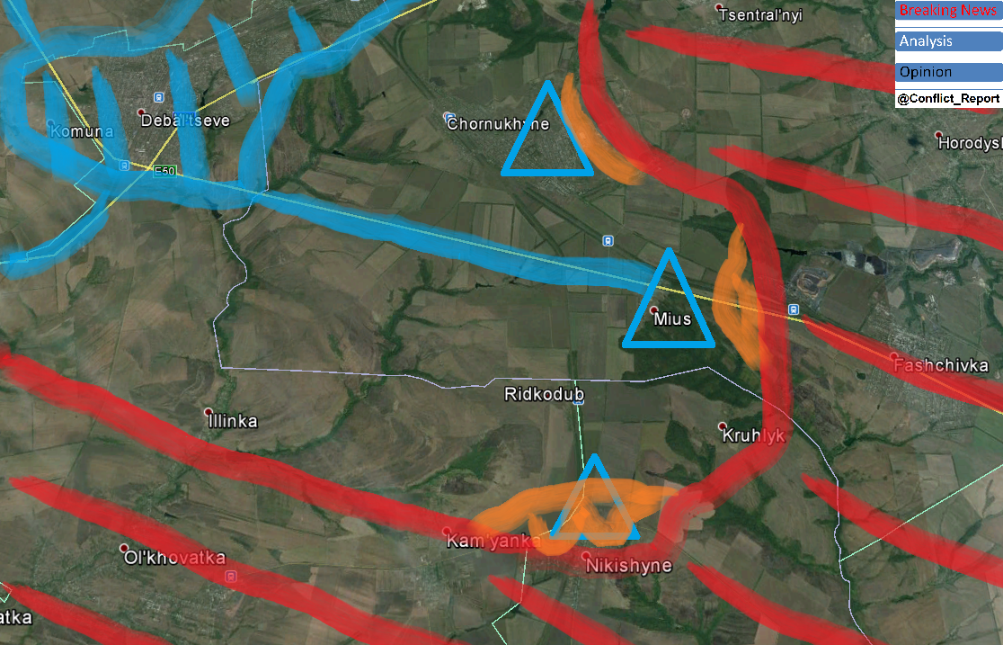
Together with Mius and partly Chornukhyne, Nikishyne was one of the three inhabited points, where the Ukrainian army built up a thin but strong (as without an alternative) line of defense south and south east of Debaltseve. The below map shows the situation from today, already including the reported territorial losses at all three defense points over the last 24 hours (especially the loss of Nikishyne).

Nikishyne

The defensive line was established 5 months ago and reinforced since then. There is virtually no fortified fallback level between Nikishyne and Debaltseve plus capturing one of the three strongpoints opens the flank to the respective two other ones, possibly leading to a chain reaction in military setbacks.

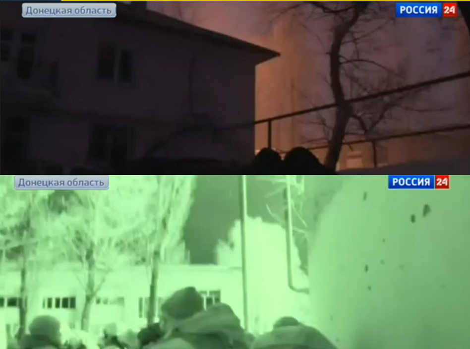
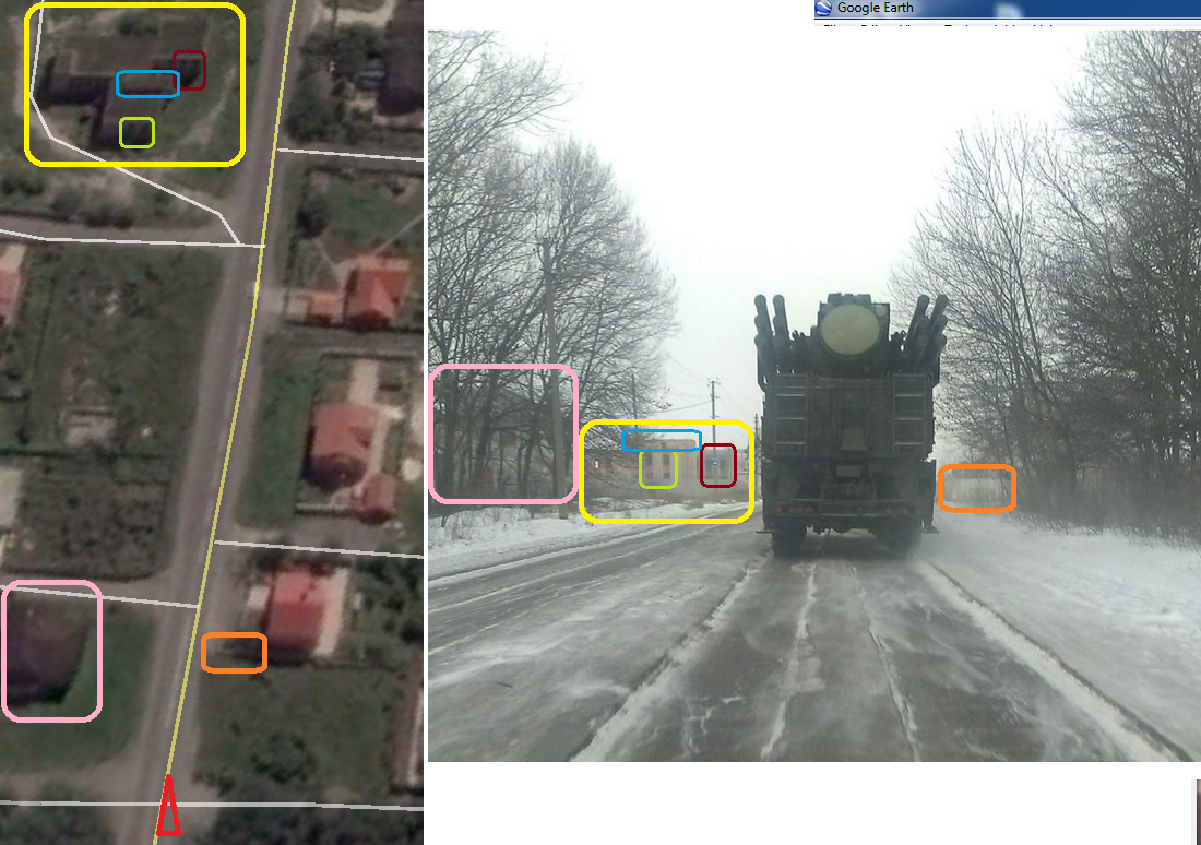
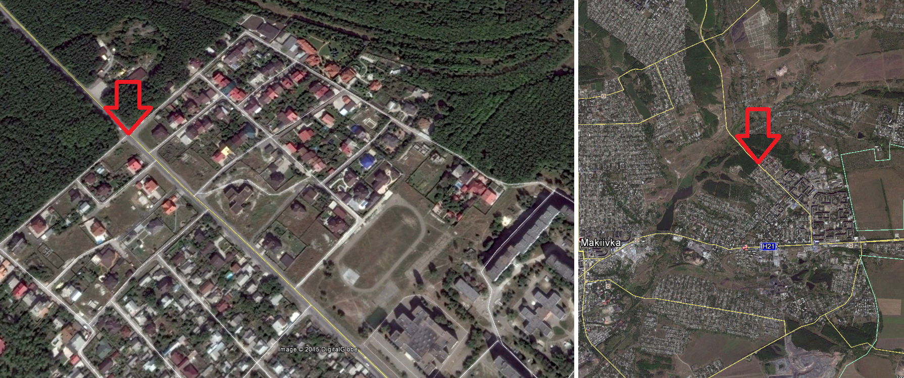
First Russian footage from Nikishyne showed the village from a drone above – an increasingly popular tool by Russian media to prove their claims – as well as the administrative building in the center of the settlement. And indeed, this footage made it possible to verify the location.

drone Nikishyne

Nikishyne from above

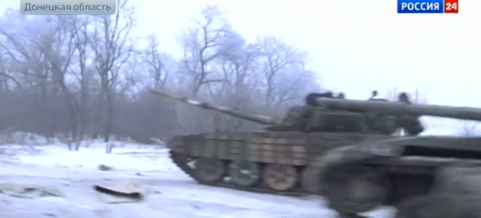
Shortly after more Russian media footage was published, once again proved that regular army main battle tanks (of the type T-64BV) were involved in the storming operation.

T-64BV

T-64BV in Nikishyne

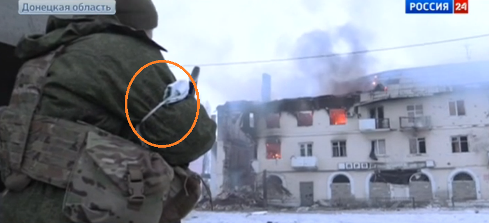
At the same time, more footage showed that the Ukrainian line of defense north of the village consisted of a fortified trenches system, some BMP armored vehicles and anti tank guided missiles weapons. However, different from the (most probable) fall of Vuhlherisk, 2 days ago, today Ukrainian forces were not willing to withdraw until the last moment, leading to the destruction and capture of the majority of the used equipment and several armored vehicles by the Russian side.

bmp

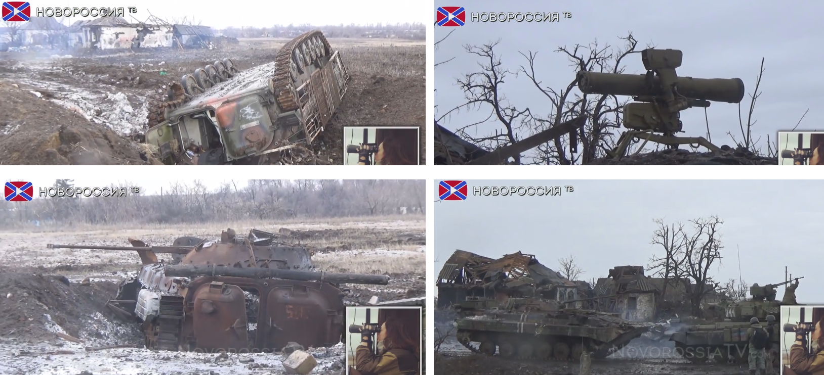
Destroyed and captured Ukrainian weapons

The apparent order to hold the position at any price is another indication of the importance of this outpost 12 km south east of Debaltseve which was at the same time the closest point to the important Russian-occupied cities of Thorez and Shakhtarsk, Ukraine held (until today).

While I cannot emphasize enough that all analysis made here, is based on footage and reports, rather than “hard facts” (which are simply not available at the moment) and that we are still looking at a more or less dynamic situation, I tried to create a (rough) situation map for February 1 2015 for Debaltseve and the surrounding areas, which is shown below.

map 1.2.2015

situation map

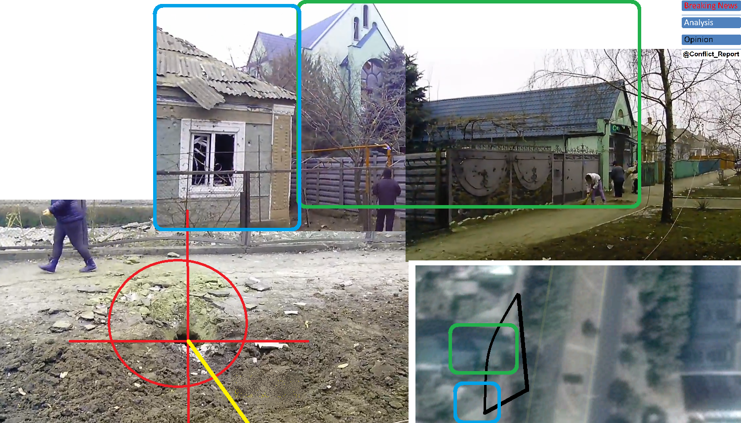
How obscure the situation still is can be illustrated with fresh geolocated footage, showing “an Ukrainian army position at a mine near Vuhlehirsk burning”. The mine is right in the middle of the territory, claimed to be taken by Russian troops so far, proving there is – for sure! – still a certain degree of inaccuracy within the general view, also affecting my creted maps from intel analysis.

mine

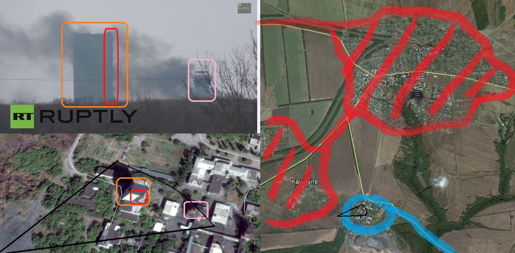
Ukrainian-held mine?!

While keeping circumstances and uncertainties like this in mind, the above situation map around Debaltseve can be taken as an approximate starting point to assess the current military situation in the area as of today. Once again, the main conclusion of such assessment can only be: Considering the current setting in and around the Ukrainian bridgehead while keeping up a purely defensive strategy can and will only lead to total defeat in the area. The fall of Nikishyne – a strongly fortified and fiercely defended strategical position in the overall defense of Debaltseve – might only by another piece in a larger puzzle. However, it perfectly fits the bigger picture and must be yet another reminder that there are only two possible options to continue: Withdraw and give up the entire bridgehead of Debaltseve … or change tactics and switch to most severe offensive operations between Stakhanov and Horlivka (for now), like Ukraine’s interior minister demanded it today.

The beginning of the end – Russian forces take Vuhlehirs’k

It comes as no surprise that yesterday around noon, strong Russian army forces started their so far heaviest assault on the 7800 souls town of Vuhlehirs’k, the second biggest town within the so-called “Debaltseve bridgehead”, a territory held by the Ukrainian army and volunteer corps between the Russian-ruled “republics” of Donetsk and Luhansk. A look at the official “ATO map” shows the strategic significance of the town, not only being the last fortress between the Russian military hub of Horlivka and Ukrainian-held Debaltseve, but also key to the only open resupply route between Debaltseve and Artemivsk, further to the west. The only road, the M03, runs just 5 km to the north east of the town and whoever controls all of Vuhlehirs’k also controls the movement between some 5000 Ukrainian troops east of it and the rest of Ukraine (map).

ato map

tactical map

Hence, it was an imperative for Russian troops to capture this town, before starting the direct attack on Debaltseve. As a matter of fact, controlling Vuhlehirs’k and the territory to its north could even avoid a direct assault on Debaltseve as a lasting siege would force thousands on Ukrainian troops to surrender without a fight, running out of food and ammunition. The general Russian strategy in the area was also described in my article from January 27, predicting “the fall of Debaltseve is inevitable […] if there is no radical change in tactics”. As there is no sign on the horizon of this change to come, regular Russian army forces began their assault from Horlivka in the west and Kayutyne in the south on January 29. While on this day, only little footage was published, showing that they overran the outer defensive line of Vuhlehirs’k, losing at least one T-72B1 and taking several Ukrainian soldiers POW, early January 30, Russian state TV published extensive video footage of the battle and its aftermath. Already on the way to Vuhlehirs’k, many Russian army T-72 main battle tanks could be seen, proving this is no further faltering skirmish, but indeed the long anticipated major push, military forces would conduct from the daily resupplied and reinforced areas north east of Donetsk city.

T-72

T-72 on the road to Vuhlehirs’k

The following footage shows the brutality of the battle that took place on the western and southern entrances of Vuhlehirs’k, where Ukrainin forces put up fierce resistance and destroyed more Russian tanks (see picture below) and likely also many troops, which are not shown on Russian footage, but were outgunned and defeated in the end, allowing the Russian army to enter the center of the town.

T-64BV

destroyed Russian T-64BV (no Ukr IFF)

Next scenes of the analzed footage show the very center of Vuhlehirs’k, where fighting still took place and residential buildings around the main intersection of the M04 highway were burning. Some Ukrainian troops seemed to still resist as shooting was aubilbe and Russian forces were still in a cautios and nervous mood.

Russian soldier

Russian soldiers in the center of the city

When the situation calmed down a little bit, Russian TV teams were able to take wider shots of the area, making it possible to geolocate and thus verify the footage. This enabled a clear confirmation of the fact that – at least yesterday afternoon – Russian forces were present in the center of the city, dominating its vital route to Debaltseve itself.

city

Geolocation of the Russian advance

At the same time, this geolocation and taking into account the previously analyzed footage made the creation of a strategic map of the battle and ground possession status possible – again – for this time yesterday afternoon. It shows that Russian forces indeed stormed Vuhlehirs’k from Kayutyne just south of it and a long the railway to the west, so from Horlivka and its suburbs. Both (footage analysis-based) assault directions were later confirmed by Ukrainian journalists and soldiers on the ground.

map

Strategic map of the battle

The crucial question remains, what happened after yesterday afternoon. While the Russian propaganda claims, it caputred most of the town and the battle is effectively over, various Ukrainian sources paint totally different pictures of the situation. The commander of the well-known Ukrainian national guard force “Battalion Donbas” for example, said this morning on his facebook page that the town was lost. Shortly after, reports from journalists on the ground said, Ukrainian forces would hold the northern and eastern part of the town, starting from the train station. This version would perfectly correspond with the created map above. However in the afternoon, the Ukrainian government’s MP and interior ministry member Anton Gerashchenko claimed that entire Vuhlehirs’k was back under Ukrainian control due to “accurate artillery strikes and daring maneuvers of our tanks”. It is telling that this most official statement so far also claimed, Russian troops only managed to capture a “suburb” of the town yesterday, but were repulsed. A flagrant lie as this article has proven. But what really happened last night? Russian media footage shows intense Ukrainian multi launch rocket system attacks. On the center of Vuhlehirs’k – and on Russian troops stationed their overnight. However, what is not shown are Ukrainian tanks or ground troops re-entering the city or any fighting from the Russian side. Instead it ends with Russian tank drivers, showing the victory sign on broad daylight.

MLRS

MLRS attacks on Russian forces overnight

Despite the fact that it remains unproven if the latest scene really shows the day after or the time before the Ukrainian artillery / MLRS “counterattack” during the night, it must be doubted that the Ukrainian army either has the technical and manpower-related capabilities in the area to launch a counteroffensive on hundreds – if not thousands – of well-armed Russian troops in the town, enyjoing a steady flow of resupplies from Horlivka and Yenakijeve. Therefore, my final assessment of the claim would be that we are talking about the same “repelling” successes as were claimed for 5 days over the new terminal of  Donetsk airport. All turning out to be untrue.

Update —

Shortly after the article at hand was published (in the evening hours of January 30), Russian LifeNews brang a report from Vuhlehirs’k, proving that the city has entirely fallen to Russian army forces and Ukrainian counteroffensives – if there were any – totally failed. Video footage does not only show heavy tank and apc forces (T-64BV, T-72B1, BMP-2) inside the town today.

tanks

Russian tanks and apc

It also contains geolocatable footage of a church in the northern outskirts of the town, showing Russian forces pointing their rifles to the north and the LifeNews “journalist” (not!) reporting without cover from possible small arms fire. According to the LifeNews report, Ukrainian forces were pushed out of the town and are shelling it with mortars and artillery from Kalynivka in the north and Debaltseve. This seems to correspond with the footage itself.

geolocation

Geolocation in northern Vuhlehirsk

From a larger distance, the geolocated footage is evidence that Russian forces took over (at least) 90% of the town including the strategic train station, which was the front line earlier this morning according to this article (read above) and Ukrainian journalist reports.

map

city map

Looking at the powerful involved forces (dozens of tanks, apc and hundreds to thousands of Russian troops), there seems to be no chance the Ukrainian army will recapture the area (as it did not recapture ANY Russian-taken area since September last year). Knowing that the Russian forces are as quickly as possible moving northeastwards, it becomes clear where their aim lies. The target is to cut the M03 as soon as possible, creating a pocket with more than 5000 Ukrainian troops in Debaltseve. Looking at the speed of their advance, this might become true within days rather than weeks.

maplarge

regional map

End of the update —

In conclusion, I might sound once again like a broken record. I wrote 3 days ago “if there is no radical change in tactics by the Ukrainian side”, it will not only lose the “bridgehead” of Debaltseve, but entire Donbas. I continued warning that “purely defensive operations against an enemy with the fire – and man – power observed in eastern Ukraine during the last 4 weeks, leads to sustained territorial losses.” I have nothing to add to these statements beside calling upon the Ukrainian government once again: Act now or start digging trenches on the eastern outskirts of Kharkiv and Zaporizhia. Because this is where the current course of the fighting is leading sooner rather than later.

Why is one of the most modern Russian army air defense systems in Makeevka?

Real news?

This article is not revealing any unexpected or surprising news. It doesn’t have to. It’s by now a known fact that Russia’s armed forces are fighting in Ukraine in their ten thousands, using their elite units (that conquered parts of Georgia in 2008) and latest military equipment.  Thus by now it is only a question of piecing together a puzzle, proving that the Russian army’s invasion is further ongoing and in full-scale despite Russia’s and western media’s denial of the situation, both referring to the invading national army as “separatists” respectively “pro-Russian rebels”. Both terms are (intentionally) misleading and wrong and it is the work of fact-based journalism to again and again pointing out that hypocrisy. Therefore the confirmed existence of the latest Russian army air defense system – the Pantsir S-1 / SA-22 Greyhound – is just another piece in the puzzle that reveals the whole picture of the current situation in eastern Ukraine.

How can the existence of the SA-22 in central Donetsk region be proven?

Five days ago on January 24, the first picture emerged of the SA-22, claiming to show it in the eastern Donetsk town of Shakhtarsk. However due to the Russian army’s threat against Ukrainian civilians critical of the invasion and revealing their ongoing equipment transfer, the picture was apparently shot secretly, is blurry and impossible to geolocate / verify. Then on January 28, another picture turned up with more ambient details.

pantsir

The Pantsir S-1

Thanks to the “swarm intelligence” of the Russian invasion critical – mostly Ukrainian – internet community, it only took a few hours until the necessary geolocation and identification was done. To independently verify this, I did it once again, coming to the same conclusion (see pictured process below).

pantsir1

Geolocation

map

Location in Makeevka

As shown in the geolocation and mapping process above, the SA-22 can be clearly located in north eastern Makeevka city, just 20 km east of the current front between Russian and Ukrainian troops. There is no doubt about it as many other analysts came to the same conclusion.

Why does the Russian army have those AA systems in Makeevka and along the front?

The SA-22 is a short- to medium range air defense systems, combining anti-aircraft artillery as well as surface-to-air missiles. Its maximum operational range is 4 km for the cannon and 20 km for the SAM with a target flight altitude of up to 15 kilometers, enough for most commercial and military jets (apart from a few very modern ones). Its appearance in eastern Ukraine can be interpreted in two ways:

Firstly and obviously the Russian invasion army wants to safeguard its forces across the occupied areas against Ukrainian air force attacks. Beside having many other – less modern – air defense systems in the region, the SA-22 gives them even more certainty of absolute air superiority over the current battlefield of Donbas.

However, there is a second, more worrying possible reason for the deployment. The Ukrainian army did rarely use any jets or air strikes in the conflict during the last 5 months. Firstly because it agreed to not do so in accordance with the Minsk memorandum and secondly because it already knows of the (more or less) advanced Russian air defense systems in the longtime-taken areas. The Russian side knows this and therefore it is to some degree unlikely that they fear attacks right now. Instead it can be argued that this system was brought in to provide (anti-)air cover for further advanced deployments than the current front and fighting arena. In a time where Ukraine feels there is no more need to stick to the Minsk agreement as the situation deteriorated too much it might hope newly occupied areas (far west of the current front) are possibly less safeguarded by Russian air defense systems, the SA-22 shows the mobility and flexibility to move short behind the – then extended and possibly dynamic – front and foil possible Ukrainian (MiG-29 and SU-27) air force attempts to stop the Russian advance in that future march.
Thus this high tech Russian army system so close to the front indicates not only a current threat but also further escalation from the Russian side for the upcoming months.

Is the fall of Debaltseve imminent? – A threat assessment.

On January 9, I predicted an imminent offensive in and around the Ukrainian city of Debaltseve, calling it “Operation Closing the Gap” as that last remaining Ukrainian stronghold in eastern Donetsk region does not only look like a cut into the Russian-held territory in Donbas, it also feels like one for Moscow and its puppet regimes in eastern Ukraine (see map below).

debaltseve

Just a couple of days later, the “much-anticipated” offensive began after Russian army troops took over the strategically important cities of Horlivka, Stakhanov and Alchevsk (1, 2), formerly held by semi-professional Russian invasion forces. Since then not only Russian media speculates about an imminent fall of the city possibly preceded by creating a pocket in which thousands of Ukrainian soldier might be caught (oftenly going by the nam “Ilovaisk 2.0 bringing into mind the encirclement of the southern Donetsk city which led to the death and capture of around 1000 Ukrainian troops).

But how big is the threat really? Is the “imminent fall” of the city just ahead?

To answer these questions, a look at the current setting on the ground is an absolute imperative. However, it appears that this setting and the military developments leading to it and continuing these days are rather a question of perspective than written in stone. So how can the qestion be answered according to the involved actors onthe ground?

Yes, if you look at the pro-Russian map of the situation and follow its creators’ (and media) reasoning. In there portrayal of the situation, the southern line of defense along the villages of Mius, Nikishyne to Bulavyns’ke has been overrun by Russian forces, the push from Zoryns’k in the north east already rached the outskirts of Debaltseve itself and the pocket in the west as almost closed with Svitlodars’k and Myronivs’kyi reached, leaving a less than 2 km broad corridor to supply Debaltseve being closed within hours or days (see map below).

Russian map

pro-Russian map of the situation, Januar 25

No, if you look at the official Ukrainian army map and follow its reasoning of the current military situation. Despite multiple indicated battles and artillery shelling in this battlefield sector, there are no territorial changes – since September 2014 (!). The southern frontline extends just north of Kirovs’ke, the north-eastern one is close to Zorins’k and in the west, Svitlodars’k and Myronivs’kyi are not even close to being reached, leaving an almost 10 km wide corridor to Artemivs’k and indicating nothing like a pocket in the naking (see map below). Comparing the map to the Ukrainian one used at the beginning of the article (from early January), it even seems like the distance between Svitlodars’k and the Russian-occupied territory has almost doubled since then putting it in an even safer position.

Ukr map

Ukrainian map, January 27

Looking at these two assessments of the current situation by the opposing parties, it becomes obvious that both include partial exaggeration and respective whitewashing of the real situation on the ground.

So how does it really look like and what is the prospect for the next days? The answer is hard to find as there is a particular lack of footage and verifiable from this very front sector. However this alone also already reveals something about the real situation. Over the last months and especially since January 2015, Russian media representatives became more and more a propaganda mouthpiece of the advancing invasion forces – mostly Russian regular army units forwardmost by now. Hence, footage of every possible advantage, even though achieved by obvious Russian army troops, is recorded and broafcasted like in the cases of Checkpoint 31 in Luhansk and Verkhn’otorets’ke in Donetsk region. Therefore, there seems to be a quite linear connection between the apprearance of footage from the respective front and military achievements in the area in question: No footage = No advantage. As there is not Russian media footage of storming and holding Nikishyne or observing the M03 between Debaltseve and Alchevs’k so far, it can be concluded that these positions were not really taken or only in sight so far and remain under Ukrainian army control.

At the same time it is out of question that Russian troops heavily shell Ukrainian positions around Debaltseve and along its only supply line since almost two and started several tank assaults on it, without going “all in” and verifiable having lost significant numbers of T-64, T-72 or even T-80 so far. According to different reports by the “Information Resistance” analysis center and the Ukrainian government, the Russian army command has amassed some 2000 troops just north of Debaltseve (mainly Alchevsk, Stakhanov, Pervomaisk) and another 2000 to its south-west (in and around Horlivka). These troops are in possession of hundreds of artillery pieces, multi-launch rocket systems and tanks of various kinds. Also therefore, this sustained and increasingly heavy fire must take its toll on Ukrainian troops from a very basic / physical point of view and is leading to increasing casualties and loss of material along the front. Numbers are sketchy, but it can be assumed that between 10 and 20 Ukrainian troops drop out of the defense of Debaltseve per day, getting killed or injured by all kind of Russian attacks (that estimated figure – some 30% of the daily Ukrainian casualties – is generaly confirmed, but only seldomly geographically located and thus not 100% certain). These troops and their damaged / destroyed equipment must be replaced it must be questioned if the Ukrainian army is able to do so for the weeks and months to come.

The following (self-created) map shows the situation as it is most likely right now on the ground, considering Ukrainian as well as Russian reports with a grain of salt. Marked are areas held by the Ukrainian and Russian army / attackers as well as verified attack direction and shelling targets over the last 24 hours.

Debaltseve map

current situation estimate

So where does all this lead?

As the Ukrainian side is running low on resupplies in manpower and equipment and the Russian side seems to have an endless flow of new arms, professional soldiers and sacrificable fighters (among them confirmed Russian criminals from Tyumen and Rostov, being forced to fight in Ukraine to avoid their respective prison terms in Russia), there seem to be no sustainable realistic outlook of holding the Ukrainian front as it is. It remains dubious if the Russian side has already started to use its elite army forces from the 58th army of the Southern Military District, which are also confirmed to be active some 20 km north of Debaltseve. The only mention-worthy tank assault so far happened on January 25, coming from the Luhansk village of Kalynove and being stopped at the outer northern line of Ukrainian defense in Sanzharivka. If the Russian force finally decides to seriously use its main force in Luhansk, there seems no reasonable chance, the Ukrainian army will be able to hold back such assault for a very long time. This assault – in my analysis – has not started so far, but the threat of it beginning soon clearly stands in the room.

In conclusion, the fall of Debaltseve seems not imminent talking about a span of hours or days. Too many Ukrainian forces are defending a too large area to be simply encircled like it happened in Ilovaisk in late August last year. Also even if the pocket is closed in the west and the M03 is cut off near Svitlodars’k, there is a high chance that Ukraina would finally decide to go all in and attack the newly Russian-held areas to save several thousand soldiers in and around Debaltseve. This however would not change the general setting at the front and only delay the siege by some days or weeks.

At the same time, the fall of Debaltseve is inevitable intermediate-term, talking about the coming weeks and months if there is no radical change in tactics by the Ukrainian side or a – very unlikely – real ceasefire starting soon. They Ukrainian strategy of “holding the line” didn’t work around Donetsk airport, it didn’t work between Avdeevka and Horlivka and it didn’t work between Frunze and Krymske, all areas where Russian forces took control over the last 10 days only. Purely defensive operations against an enemy with the fire – and man – power observed in eastern Ukraine during the last 4 weeks, leads to sustained territorial losses with only the needed time depending on the inadequacy of forces and equipment at the respective front sector. The Russian strategy around Debaltseve is clear and openly admitted (see illustrative map below).

attack plan

the Russian strategy around Debaltseve

Without giving a crushing – offensive – response interfering with these plans and thereby forcing the aggressor into meaningful negotiations on longtime mutually respected demarcation lines, the threat of the fall of Debaltseve is as high as never before. Not within days or possibly weeks; but almost certainly at some point during the first half of 2015.

Syrian rebels capture Shaykh Maskin in southern Syria

In mid December of last year, I wrote a large article on the The Battle of Shaykh Maskin” describing how that battle between mostly moderate and Arab states-backed rebels – the so-called “Free Syrian Army” – and troops of the Assad regime developed. At this point, rebels were able to capture and secure some 75% of the city, however most of its strategic military installations remained under the control of the Syrian regime army. Shortly after that article – around Christmas 2014 – severe winter started in southern and central Syria,  stopping most of the fighting for a couple of weeks. It became very quiet around this stratagic town of Shaykh Maskin, being the gate to Izraa and Garfah, both located on the M5 highway, the only remaining land bridge between the regime-held Damascus area and the major city of Daraa in the south of the country.The attached map (not by me!) show how thin the respupply line to Daraa is right now and that regime forces are under extreme threat to lose its remaining strongholds in the south.

B8ROrc2CQAA9j6l

The situation in Daraa province in January 2015

Cutting this bridge would at the same time equal a huge advantage for rebels in Syria’s south, one of the last places across the country, where the pro-democracy revolution was not hijacked by islamist extremists or – literally – destroyed by the Assad regime.

Howsoever, information started to flow again on January 25, showing major developments on the fronts across the northern part of the city. This indicates that the (almost) media blackout over the last month was deliberately to not reveal too much about the usage of fresh weapons and troops used in the offensive. From precisely geolocated footage, it became clear that rebels were able to capture all remaining military installations across the town, namely the Brigade 82 headquarters on a hill overlooking most of Shaykh Maskin, the main base to the north east of the town, the radar base where rebels were able to seize an SA-6 and the weapons storage base some 3 km north of the city. The below map shows all advances between mid December 2014 and January 26 2015.

shaykh maskin

Strategical map of Shaykh Maskin, January 26 2015

The battle for Shaykh Maskin lasted from for a duration of almost 3 months and ended with the total victory of Free Syrian Army and other rebel forces. This is another indication that – different from the Damascus region, Aleppo and areas mostly to Syria’s western borders (with the sea and Lebanon) – the regime control over southern Syrian is increasingly diminishing and about to collapse during 2015. This can be mainly explained by the close-by Syrian-Joranian border via which weapons and trained fighters seem to enter Syria since several years, sometimes more, sometimes less. Those forces are trained and armed by other Gulf states with the consent of the United States, being proven once again by the modern weapons used in the battle for Shaykh Maskin and its eventual fall to the rebel army.

Proving Russia’s guilt of the Mariupol massacre – it’s not that difficult!

Today, the aggression versus the Ukrainian people reached a new peak when close to a hundred Grad missiles hit residential eastern neighborhoods of the port city of Mariupol, a hot spot of fighting since Russian army forces invaded the district of Novoazovsk in late August last year and advanced almost until the city limits of Mariupol. 27 Ukrainian civilians (including 2 children) and 1 soldier at a nearby checkpoint were killed plus another 97 civilians injured in what can be described as a deliberately caused massacre of the local civilian population.

But who caused that massacre? The answer is too obvious. Nonetheless, this article points out a 100% reliable blame, leaving no doubt who killed another 27 civilians after the Leninsky and Volnovakha bus attacks over the last days, killing 26 people and clearly bearing the hallmarks of the same criminal regime. At the same time it should be emphasized that it is not rocket science to determine who fired a missile, knowing some technical data of the weapons involved and having an elementary knowledge of the local geopolitical context.

Step 1: Geolocating footage, showing an impact crater

Minutes after the attack occurred, multiple videos appeared on the net, showing burning buildings and damage and some of them also direct impact locations and craters of the used missiles. In just another few minutes, these videos can be geolocated, using widely known open source maps.

impact

Geolocation of the impact

The above example shows how the footage can be affiliated with a an exact location and camera angle. A closer look at the impact gives clear indication of where the missile came from. This should be marked for further analysis.

Step 2: Determining the approach angle

Having done this, it is only a question of knowing how to use a compass to determine the direction of which the impacting projectile came from on a local scale. The camera angle as well as identified fixed objects in the footage / on the connected map give a precise impression of the approach angle of the missile that caused the damage and especially crater in the picture. It came from the east, slightly more than 90 degrees.

direction

approach angle of the missile

Step 3: Providing technical and geopolitical context to the physical facts

The last step is to put the obtained data in context, meaning to lean back and ask what this means in a broader political – and in this case – spatial context. Hence the geopolitical circumstances – the “Who owns what?” – as well as the technical features of the weapon involved must be taken into consideration.

Starting with the technical background, we are talking about a large volley of BM-21 Grad missiles, having an absolute minimum range of 4-5 kilometers, depending on the type. This means the origin of the missiles that hit the area is located at around 5 km (or more) to the east.

Finally, a look at the military-related territorial setting in the surrounding areas brings light into the darkness. The affected area is located on the eastern outskirts of Mariupol and literally “the last line of defense”. Ukrainian army and national guard forces are stationed up to around one kilometer to the east, overlooking an area of maximally 2 further kilometers. After this extends around 2 km of “no-man’s-land”, followed by Russian-held territory stretching on a North-South line, crossing the village of Lebedyns’ke (see map below).

larger map

Strategic map

This area was directly invaded by the Russian army in August 27 last year, transferred to “none-professional” Russian invasion forces and a tiny number of local separatists during several months of the ceasefire and in late December reoccupied by a large Russian army force, preparing and starting an coordinated push with units all other the front since then. Simultaneously, the Russian force accumulated large quantities of weapons like the type of MLRS used in today’s attacks on Mariupol. Weapons which in its mere number and infinite resupply of ammunition can only be provided by a well-orchestrated military and logistic campaign on a national level.

In the end, the answer to the initial question of “Who caused the Mariupol massacre?” can be given with a certainty of 100%, looking at the comprehensive though straightforward analysis above: The armed forces of the Russian Federation. This is just another chapter in its aggressive and inhuman campaign vs. eastern Ukraine and the values of the international community which must be answered immediately and stopped by all available means.

Hard evidence, the regular Russian army invades Ukraine

Over the last 72 hours, increaring reports of regular “Russian army” deployments inside Ukraine emerged, not only from blogging insiders and investigative homepages, but also from the Ukrainian president and army command themselves (a very rare move, despite the widely dominating verbal calming down attempts). Nonetheless, footage to prove such “new” statements was lagging over the first days, a fact, understandable under the current circumstances of the Moscow regime, not willing to uncover its full-scale military invasion into Ukraine. However since yesterday, January 22, several undeniable video sequences from different front sectors across Donbas emerged, undeniably supporting the Ukrainian intelligence reports.

1. The Grad-K in Donetsk

Most bulletproof evidence is the appearance of the most modern Russian army 2B26 Grad-K system mounted on a KamAZ-5350 chassis (pictures below) just a few kilometers from Donetsk airport. This refurbished BM-21 system was revealed in 2011 and delivered to the Russian armed forces from 2012. It is ONLY operated by the Russian army itself and there is no other source of such weapon system available.

Grad-K

The Grad-K in Donetsk

Further details are striking. The systems appears in Donetsk in fresh winter camouflage showing it was prepared for winter war and surely sent in under the current weather conditions. Also the “rebel” camera man pulls down his camera as soon as it leaves the line of 4 older BM-21, mounted on Ural-375D (a system, delivered in its hundreds by the Russian army to its proxies and forces in Donbas). He obviously has the orders to not film such system in that area and that time. However, he lifts it up 4 seconds too early clearing the sight of this 100% Russian army weapon system.

2. The BM-30 Smerch in Makeevka

In the evening of January 22, footage of a BM-30 MLRS system appeared, claimed to be taken in Makeevka, just a few kilometers east of Donetsk and less than 20 km to the nearest frontline. The BM-30 “Smerch” (also known as 9A52-2 Smerch-M) is the heaviest multi launch rocket system (MLRS) in its “family”, exceeding the smaller BM-21 and BM-27 in its caliber (300mm) and range (up to 90 km). Independent geolocations of the footage by several expertes (e.g. Dajey Petros and me) confirmed the the location exactly where it was reported to be, so (very) close to the frontline for a system with such operational range.

BM-30

The BM-300 in Makeevka

The system has never before been recorded in Russian-held territory for a simple reason: It was not there. While the Ukrainian army lost several weapon systems during the created boilers in August and September last year to Russian invaders, the BM-30 was always able to stay far behind the front due to its range and was never captured by “rebel” forces or the vast majority of Russian mercenaries and Russian army forces. Knowing that there is no credible narrative for the appearance of such heavy and exclusive system “in separatist hands”, the Russian invasion command abstained from sending the system to Ukraine over the following 4 “ceasefire” months, despite deploying thousands of other military vehicles like tanks, apc and smaller MLRS. However now that it goes “all in” and started an offensive to take entire Luhansk and Donetsk regions (and even more), the Russian army command decided to not spare this long range, deadly tool of warfare anymore, no matter the fact that this is another 100% evidence, it is fighting in neighboring Ukraine.

3. More proof

There is much more (very) recent evidence that Ukrainian intelligence and all “real” / evidence-based experts are right, calling the latest developments a flagrant and open Russian aggression against its western neighbour. Just like the pictures of Russian Far East soldiers with green ribbon after taking Checkpoint 31 in northern Luhansk region, the secret recording of a 500+ troops Russian Army convoy, approaching the town of Stakhanov or footage of a military makeshift bridge, built by Russian sappers over a river in Luhansk with the help of a MT-55A AVLB. …

But all these “smoking guns” might be disputed and denied as “so or differently explainable”, despite all indication leading into the same (Eastern) direction. Meanwhile the two above mentioned cases, recorded over the last 24 hours, provide sufficient evidence, regular Russian army troops are not just “located all around Donbas, ready to move in” – like acknowledged by many western media and security sources – but fighting on all front sectors inside Ukraine, reinforcing and replacing its pre-existing invasion forces.

PS.

This article only lists NEW evidence that appeared over the last 24 hours and after the statement of Ukrainian president Petro Poroshenko in Davos. Of course, multiple Russian-army-only equipment appearances over the last 7 months (T-72B3, T-72B1, BPM-97, GAZ-3937, BTR-82A  etc.) leave no doubt that it was and is the Russian army that exclusively supplies all anti-Ukrainian forces in the Donbas with weapons and exerts its surpreme command over them.

The fall of Donetsk airport – shedding light on the latest developments

After 3 days of complete media blackout from Donetsk airport and one day after Russian invasion forces proved to have captured several Ukrainian troops at the airport, fresh footage from inside the new terminal appeared.This footage leaves no doubt that not only the entire terminal and facility building complex (with the possible exception of the collapsed tower and radar station) are in Russian hands, but also that Russian media and troops can move freely over the apron north of the terminal between the five gates of the former airport, leaving no doubt of not being afraid by any opposing forces close-by.

Airport1

Geolocation of Russian media footage from January 21

safe zone

the situation on January 18

Why can this be said with almost 100% certainty? The last article, dealing with the airport, was written on January 19 and reflected the “who controls what” situation from one day earlier, namely January 18. Looking at the analysis of the different possessions within the building from that day, it becomes clear that only parts of the western and north western front were still held by Ukrainian forces, while most of the terminal was already under Russian control already – proven by lots of footage over the previous days. Latest available footage from Cyborgs within the building ( “playing soccer”) could be located between the very left and second from left gates. This area is entirely under Russian control now, leaving no doubt that there are no Ukrainian soldiers left in the terminal.

Other footage, showing a panorama of the northern gates section of the terminal, adds to the impression that this is no “sneaked” – or even “faked” footage, but reflects the real situation in the area. It was recorded between gate 2 and 3 (from the left) and shows both the destroyed gates with the foggy horizon to the north and two destroyed Ukrainian T-64 plus several more army vehicles, lost due to the extreme shelling and overwhelming ground troop attacks, never short of “human resources” to throw (and sacrifice) into the battle.

gate

Gate 3

tanks

destroyed T-64

It is not totally clear, when the terminal fell completely to Russian troops but the story around the captured Ukrainian troops from yesterday morning seems to give at least some indication. According to the Ukrainian army they were sent to evacuate wounded fellow troops and resupply them with ammunition. However the claim that an incompetent commander “missed the terminal by 800 meters during fog” sounds not very reliable, giving the fact that he only had to follow the taxi ways from Pisky. Instead – sadly – the version some of the captured Ukrainian troops said in Russian confinement sounds slightly more reliable, despite it has to be taken with a pinch of salt. That version claiming to not knowing the situation at the airport plus the claim of Russian invaders that those troops “just ran into us” indicates the formerly described “safe movement zone” (map further above) ceased to exist between January 19 and January 20, despite heaviest artillery, MLRS and tank fire on all Russian positions by the Ukrainian defenders N and N-W of the airport.

But as so often in war, the truth is somewhere in the middle. On January 20, Russian media showed 5 Ukrainian POW and claimed to have killed 6 more, which surely does not mean that this was the force to recapture – or only attack – the airport. The next morning, Russian channels aired footage of captured Ukrainian troops in Donetsk hospitals, suddenly saying, 16 of them are treated for their injuries at the moment. This is speculation of course, but it appears that those “new” captured – dusty and injured – troops might have been the remaining Cyborgs, Ukr troops were to evacuate of reinforce the day before. As no help came, they might have decided to do the only reasonable in the light of the military superiority of the enemy. – Almost all alternatives are much worse. Russian propaganda footage also showed a number of bodies at the taken over terminal, claimed to be Ukrainian troops but without showing proof for that claim …

Whatever really happened, it looks like the last relevant Ukrainian position within the perimeters of Donetsk airport fell between January 19 and January 20 with reinforcements (/suppliers) as well as more troops from inside the terminal going into Russian POW-ship. This means that all Ukrainian claims since then that they are “still in the buildings and the airport” like states in the evening of January 21 are rather propaganda to keep up the moral than fact-based reports. The only position that remains unknown is the one of the airport’s destroyed tower, but not possibly under fire from 270 degrees, it would make little sense to hold that ruin.

Ukrainian forces are not defending, but attacking the airport now, lagging the manpower and general strength to halt or even repulse the Moscow-sent masses with their almost endless stream of mostly crude but deadly weapon systems and ammunition.

The final map shows the situation around Donetsk airport as it might look now according to this assessment. As it is still very fluid – meaning Russian troops could have captured even more right now, especially around Pisky – it reflects the actual state of affairs as it was available in the evening hours of January 21.

map 21.1.2015

Map based on assessment – 21.1.2015

This article is not about putting blame on anyone for the current military development. Only so much be said: The way, the Ukrainian government and army is leading the war at the moment – it is losing it and with it large parts of Ukraine itself.

The Russian army offensive in northern Luhansk region – Day 1

As if the recent (almost) defeat of the Ukrainian army in the battle for Donetsk airport wasn’t enough, the Russian invasion command in Moscow once again decided to pile the pressure on its western neighbor by starting its long-awaited offensive along the Bakhmutka highway in Luhansk oblast in the early hours of January 20.

In the end, this move didn’t came as a surprise. Around noon of January 19, the Ukrainian government decided for the first time since August 2014 to call a duck a duck as it observed almost 1000 Russian army troops – two tactical task forces in battalion size – crossing the Russian-Ukrainian border in eastern Luhansk region. The invasion force, seen entering Ukraine by its intelligence services, was too big to be described as “foreign-backed terrorists”, a term usually used by the peace and calm-seeking Ukrainian government to not further provoke Russia into more aggressive steps. Shortly after, the track of the two battalions was lost, but it became obvious that they were not approaching Donetsk city where fighting is fierce, but due to the steady flow in manpower and weapons, slow but steady Russian advances could be seen since the start of the latest offensive on January 1st. Also possible reinforcements for the Donetsk forces would probably have entered Ukraine from border points closer to the main invasion base, still active 50 km south of the border. Entering via Izvaryne would have been a detour.

So it came as it was bound to happen. In the early morning hours of January 20, dozens of artillery pieces opened fire on “Checkpoint 31”, located on the junction of the so-called “Bakhmutka highway” – a road leading from Luhansk city to the larger northern towns of the region – and the small road T1317, connecting Russian-held Frunze, just 3 km south, with the strategical village of Krymske on the bank of the river Seversky-Donets, the natural borderline between Russian- and Ukrainian-held Luhansk region. The artillery fire lasted for 6 hours, beating down the Ukrainian troops manning the (frontline) checkpoint. But it was just the beginning. Shortly after artillery became silent, eight Russian army tanks came down the road from Luhansk and pounded the checkpoint, forcing the Ukrainian defenders to retreat along the T1317 north towards Krymske and T1303 towards the west. Reports say, Russian forces also attacked from Frunze, but this is not confirmed. Only known “footage” (sounds) of the entire attack comes from a “(New-)Russian” media channel, showing the “emergency evacuation” of civilians from nearby Frunze during the assault.

Around the same time the direct attack on Checkpoint 31 started, Russian army forces with armored vehicles and ground forces also attacked the village of Zholobok, 7 km to the west, from nearby Donets’kyi. The aim of this attack seemingly was to cut the withdrawal path of retreating troops from CP31 and to attack CP29, which lies just north east of Zholobok, halting it from sending reinforcements to the east. According to the Ukrainian army, several attacking forces at this battle were destroyed and the army lost the village but managed to regroup at nearby CP29 and is still holding the position. The overall attack on both sectors of the front was – according to Ukrainian observers on the ground – not only the the obvious expansion of the Russian-held territory along the strategic highway, but also the encirclement of Krymske in the north, baring Russian forces from further advances along the Severskyi-Donets so far.

The below situation map summarizes the battles that took place today to the best of my knowledge and information. Blue marks previously Ukrainian-held territory, read, Russian held, arrows attack directions and orange the newly occupied area according to my (informed) estimate.

bakhmutka

In the evening of January 20, two things are clear:

Checkpoint 31 and most probably also Zholobk are still held by regular Russian army forces while the Ukrainian defense ministry says, it is fighting back at the moment, trying to regain control of the lost territory and especially CP31. These attempts were not successful until midnight and the NSDC spox already announced that IF the army would continue the fight or pull back would be up to its command, putting further doubt into its abilities to withstand the superior Russian army units. Astonishingly, also until January 21 local time, the Ukrainian army did not decide to use its air forces against the self-proclaimed Russian army offensive, 70 kilometers from the common border…

At the same time, partly confirmed reports of further three Russian army task force groups (each 300-500 men and equipment) waiting to enter Izvaryne or already inside Ukraine and on the way to Luhansk emerged in the evening of January 20. Their sighting plus the confirmed first overwhelming victories (described above) are unambiguous signs, Russia’s thirst for more Ukrainian soil under the pretext of saving “its ethnic population” is by far not satisfied yet and the worst in terms of military aggression is yet to come.


Important sources of battle details

Who controls what of Donetsk airport – a clarification attempt

On January 15, the Russian invasion army’s “final push” started on the – until then – Ukrainian army and volunteer forces-held Terminal one and the airport’s control tower. Since then, the war for the airport es escalating. On the ground and regarding the information who controls what. While the Russian side claim, it controls the entire terminal since January 16, the Ukrainian administration claims, it “repelled” all attacks and “holds the terminal”. So one side lies?! Not sure as the truth mostly is located somewhere in the middle – or in this case: in different parts of the large terminal complex. Later more on this.

Since the start of fighting action inside the terminal, I am trying to make sense of the video material coming out of the building, trying to verify reports and claims of both sides. Doing this, it is not as easy as many pro-Ukrainian “experts” claim, saying: “Russia always lies. Their media is a pure propaganda tool” or even “This cannot be the terminal as the Ukrainian army holds it, according to its statements.” – Of course: Russia lies! They transport their propaganda in every second they report from and of occupied Donbas. But the sheer existence of footage from certain areas and locations proves that there is a true core in what they claim from a very basic, almost “physical” point of view, meaning: When you report from the terminal and prove this with – meanwhile – hours of footage in 5 days, you are in the terminal, no matter what your or the opposing propaganda makes our of your claims. Having said this, I can and must use all available footage from the area instead of believing what either side claims to explore the current situation and who controls what of Donetsk airport. And when 95% of that footage is from the Russian side, I will mostly use it, no matter its origin and propaganda purpose (as for the reasons I pointed out above). So this analysis is an attempt, based on as much footage and recent evidence as possible, without having the guarantee to be entirely correct.

The situation around Terminal 1 – in my informed estimate – looked as follows yesterday afternoon, January 18 2015 (Red: Russian-held, Blue: Ukrainian-held.)

now

Situation around Donetsk airport terminal 1 in the afternoon hours of January 18, 2015

Most of the area is held be Russian forces, namely “Battalion Spartak” – Russian army forces with some paid mercenaries from Russia and very few Ukrainian-born fighters-  under the leader of terrorist “Motorola”. This includes – of course – the entire ruin of terminal 2 and even the apron in front of it but also the car park used as a bridgehead for Russian BTR-80 to bring new troops and ammunition to the terminal itself, almost hourly (see image below).

car park

The “bridgehead” car park of Donetsk airport.

However, the Russian-held area also includes most of the new terminal building itself, including the entrance area, the main airport hall, the entire eastern front facing terminal 2, the front area overlooking the gates as well as parts of the logistical facilities inside including the luggage transport section. (Please click on all links to see tweets with pictures proving those claims over the last 3 days.) On January 17, the Russian invasion army even regarded the northern terminal side next to the gates as safe enough to bring terrorist “DNR” leader Zakharchenko in, the possible highest profile target for Ukrainian authorities. While it can be argued that he surely was under the threat of being hit by Ukrainian artillery inside the terminal, under no condition would Russian have moved him inside it if there was the danger of armed confrontation with Ukrainian troops inside it. So they were VERY certain this would not be the case.

zakharchenko

Zakharchenko in the terminal on January 17

So do they control “all of it” as they claim?Surely not. There are 3 reasons speaking against that allegation:

1. There is one piece of footage, posted by the defending Ukrainian “Cyborgs”, playing soccer inside the terminal area from January 16. Indeed this footage is 3 days old and a quick geolocation shows, it is recorded in the outer North Western ground floor of the termminal. However, it proves that at least 1 day after Russians claimed the terminal was fully taken, this was not the case. No video from ins

2. On January 15, Russians posted footage from all sides of the terminal, also looking out of the western front, recording shelling of the Donetsk airport tower. Since then no such footage appeared on the net. Also no other evidence, they are still in control of the western part of the building. This could mean, the Ukrainian army indeed “repelled” the Russian offensive in this part of the terminal around January 16, securing the crucial safe corridor to reinforce and resupply its defending forces in the western part of the complex. However, this is all it achieved, afterwards inflating this tiny success to a “full control” in its PR campaign… The January 19-created map below shows not only who holds what according to my analysis, but also “safe movement zones”, saying a lot about who controls which frontage and is able to fire from it and cover its area. Hence, these “safe zones” are not safe from medium range artillery and MLRS fire, but from direct enemy fire from the nearby buildings.

safe zone

“safe zones”

As it can be seen on the map, Russian forces as well as Ukrainian forces seem to have safe movement zones via which they are able to resupply / reinforce their forces and evacuate the injured – leading to the last point proving Ukrainian forces are still holed up in a small part of the terminal:

3. There are casualties among them. This point might sound odd at the first moment, but becomes clearer thinking about it. Ukrainian forces suffer multiple casualties inside the terminal which means they are still there. Just yesterday, 14 Cyborgs were injured inside it and evacuated under the cover of darkness this night, according to the Ukrainian NSDC. Over 50 were killed and injured over the last 5 days. Of course, one could argue that to save the appearance of an Ukrainian presence inside it, it could artificially “move” those casualties into the terminal from other locations, but this seems very unlikely as several volunteer activists confirm such dangerous MEDEVAC operations.

So what to make out of it?

According to my analysis, Russian forces control 90% of the terminal right now plus the entire southern and eastern surroundings of the mostly destroyed building. At the same time, Ukrainian Cyborgs are holed up in a small ground section in the north west of the terminal, still having a heavily embattled resupply line thanks to massive own artillery support and the inability of Russian artillery in Spartak and elsewhere to hits that part of the terminal.

At the same time, this situation didn’t change largely over the last 4 days of heavy fighting. Russians couldn’t oust last defenders from the terminal and Ukrainians were unable to recapture significant parts of it let alone the strategically important surrounding areas and facilities. – If the last 5 months of fighting proves anything then “Who is in the terminal stays in the terminal.” and can only be ousted by months of heaviest artillery and missile shelling as well as massive own casualties (the Russian lost at least 500 men before being able to enter it). The last days showed that this is also valid for Ukrainian counterattack attempts. As a consequence, the current development must be seen as another military setback for the Ukrainian army and the government’s strategy to hold the frontline never mind to “recapture Donbas” or just the entire airport as president Poroshenko promised yesterday.

It remains to see if the situation is really as “fluent” as many analysts claim since almost 4 days and territorial changes in and outside the terminal will appear in the short term. This article was an attempt to make sense out of what it looks at this moment and not even now as things MIGHT have changed overnight after massive clashes yesterday evening. Still it should be seen as a “situation mark”, from which further reasoning can start without falling into the trap of propaganda and inflated claims by either side involved in the conflict.